Alien Anomalies

Members Login
Username 
 
Password 
    Remember Me  
Post Info
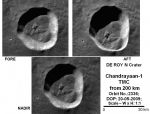
TOPIC: What happened to all the data from the Indian Chandrayaan-I Moon mission ?


Teaching the truth

Status: Offline
Posts: 1921
Date:
RE: What happened to all the data from the Indian Chandrayaan-I Moon mission ?
Permalink  


masjosh, thanks for the comments and link. Strangely there are only 5 Moon shots in the whole gallery at the link you posted which is the Indian Space Agency website.

I dont know why they do not link to the official data site from there for people who want more images. Perhaps it is because not many people have the required software to view the img files, or perhaps they want us to be happy with only the 5 images they give us.


__________________


Member

Status: Offline
Posts: 223
Date:
Permalink  
 

http://isro.gov.in/pslv-c11-chandrayaan-1/pslv-c11-chandrayaan-1-gallery


__________________

The whole universe is to the observable universe, as the observable universe is to an atom. - Alan Guth


Member

Status: Offline
Posts: 223
Date:
Permalink  
 

This is worth a look.  Sorry for the gigantic image, using my phone in bed! 😴

8-deroyn.jpg


Attachments
__________________

The whole universe is to the observable universe, as the observable universe is to an atom. - Alan Guth


Senior Member

Status: Offline
Posts: 896
Date:
Permalink  
 

It is suspicious.  Even the little they have released is just horrible quality.  All of there missions seems to be like this.

The Mars photos are a joke.  


__________________


Teaching the truth

Status: Offline
Posts: 1921
Date:
Permalink  
 

The email reply from the Indian Space Agency gives this link as the official Chandrayaan-1 repository


__________________


Teaching the truth

Status: Offline
Posts: 1921
Date:
Permalink  
 

No-one seems to ask where is the 70,000 images that were supposedly sent back to earth? I have sent an email to the Indian Space Agency, but so far....nothing. Maybe they will reply and if they do I will post it here.

My other posts about this
first release of Chandrayaan-1 Moon Mineralogy Mapper (M3) data.
Chandrayaan-I found tunnels on the Moon

They are NOT on the Indian Space Agency site as far as I can find out.  I wonder what happened to those images, maybe they were "accidentally destroyed" like the Apollo Moon images that NASA did not want found.  70,000 images is a LOT of data and even if that figure is not accurate, then say 10,000 images is still a lot.


There are 5 images of the Moon on the "Latest Images" page official ISRO Indian Space Agency website

Link
...has made 3,000 revolutions around the Moon. Besides sending more than 70,000 images of the lunar surface which provide breathtaking views of lunar mountains and craters,...

and the reason for failure of the comms module was...Link
Asked about the ISRO’s admission that a “miscalculation of the moon’s temperature” led to the satellite’s abrupt end on August 29, ISRO Chairman G. Madhavan Nair said: “Unfortunately, the reflection from the moon was much larger than expected and higher than what the literature data indicated.” How many spacecraft went to the Moon before 2003 when this mission was started? You would have thought that was a MAJOR planning requirement for a multi-million rupee mission, to make sure your spacecraft did not get fried like an egg. No, I think it was a deliberate attack by NASA.. or the aliens.

Found this in a pdf file giving mass of spacecraft etc Link
India plans to launch the Chandrayaan-1 mission to the Moon in February, 2008. This 550 kg spacecraft will enter a 100 km polar orbit and map the Moon for 2 years. It’s core payload includes monochrome imaging at ~ 5 m/pixel, a hyperspectral imager (color camera) that images the Moon at 80 m/pixel, a laser altimeter (1 Hz freq.) and an X-Ray fluoresence spectrometer to map the light elements (e.g., Si, Al) of the surface

The principal mapping goal of Mini-SAR on Chandrayaan-1 is to cover from 80° to 90° at both poles

Link
data products include complete maps of both polar regions of the Moon at 75 m/pixel. All raw data as well as processed data including higher order products such as mosaics will be made available to the scientific community, both through the international portal of the Indian Space Science Data Center and through the Geosciences node of the NASA Planetary Data
...
The Mini SAR instrument operated nearly continuously for the two month period planned and collected SAR data for over 90% of both lunar poles as well as selected test and calibration strips of several non-polar targets of a variety of terrains around the Moon. Data quality is excellent and preliminary results are presented here and in several companion abstracts.
...
The south polar region shows similar relations, except that it has more extensive low CPR terrain and fewer anomalous high-CPR interior craters. Massifs that make up the rim of the South Pole - Aitken basin show high CPR, similar to results seen in basin massifs in the near-equatorial Apennine mountain range. These results are somewhat unexpected; lunar massifs are some of the oldest terrain on the Moon and are expected to be covered with thick, fine-grained regolith. Downslope movement has apparently removed much of this material, exposing an abundance of decimeter-scale blocks.


Link
August 29, 2009 – Chandrayaan-1 Mission Terminated

ISRO lost radio contact with Chandrayaan -1. After failing to re-establish contact for more than 24 hours, ISRO terminated the mission. Though this news is unexpected for all of us Chandrayaan – 1 achieved 95% of its objectives.

Overall, during its ten months of existence, Chandrayaan -1 completed 312 days in orbit and provided large amount of data. It was declared two years mission which is abruptly ended now. Chandrayaan-1 had completed more than 3400 revolutions around the moon. It had dispatched over 70,000 images of the moon surface.

The mission is abruptly ended but all the data was downloaded from the spacecraft on a regular basis and no scientific data is lost. John Yembrick, public affair officer (space operations) NASA headquarters, said, "NASA has obtained an abundance of data during our operations. Work is on to analyze that information."


Link
In an article titled “Detection of potential site for future human habitability on the moon using Chandrayaan-1 data” in the latest issue of Current Science, lead author A S Arya and four other scientists from the Space Application Centre said “a buried, uncollapsed and near horizontal lava tube was detected in TMC stereo images of the Oceanus Procellarum area on the Moon”.

The Oceanus Procellarum is an area on the moon formed by volcanic activity. It is a little smaller than the Mediterranean Sea and lies on the side of the moon visible from earth. The particular lava tube lies slightly north of the lunar equator. Lava tubes are not unique to the moon, the authors note, saying studies on volcanic fields like those on the islands of Hawaii show most lava tubes “remain partially void”.

Where are all the volcano and gelogical evidence for an active planetrt body? Where is the lava, where is the surface evidence? They need this to explain the "lava tubes" and rille which have been explained to us as old geothermal features of a past age. Look up the "ringing like a bell" quote and see the mess all that brought up and how it was explained away in a very poor way.

This 2006 NASA article on moonquakes says that the Moon is geologically active.


-- Edited by qmantoo on Friday 17th of March 2017 03:45:12 AM

__________________


Page 1 of 1  sorted by
Quick Reply

Please log in to post quick replies.

Tweet this page Post to Digg Post to Del.icio.us


Create your own FREE Forum
Report Abuse
Powered by ActiveBoard