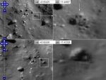
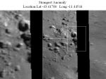
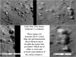
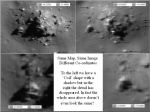
Alien Anomalies

Members Login
Username 
 
Password 
    Remember Me  
Post Info TOPIC: Anomalous Areas appear twice in LRO Map but with Different Co-ordinates


Teaching the truth

Status: Offline
Posts: 1901
Date:
Аномальные зоны появляются два раза в МРО Карту, но с Разными координатами
Permalink  


The Genealogist wrote:


Slide 4 begs the question Is this a glitch or is their something to hide??

Observations or ideas welcome...


 The same problem can? confuse  http://alienanomalies.activeboard.com/t53764935/twins-and-triplets/


-- Edited by goggog on Thursday 13th of June 2013 03:24:49 PM

__________________


Veteran Member

Status: Offline
Posts: 486
Date:
Anomalous Areas appear twice in LRO Map but with Different Co-ordinates
Permalink  


Although Arizona have provided us with a new LROC Quick map on their website I have noticed some very strange overlays which have started to appear especially when using the highest magnification of 0.5 m per pixel. They do not appear when using 1m per pixel at least in the locations I am working on.

At the moment I cannot see any reason for them doing this unless its a glitch in the system. There has always been a degree of duplication at the edge of image strips (as seen earlier in this thread) but this is a completely new development.

The following slides of Tycho crater serve to illustrate my point. (Location supplied on the image)

Slide 1 shows how these squares are appearing in Tycho crater.

Slide 2 highlights these squares in yellow and shows landmarks for comparison in red

Slide 3 compares a lower magnification (1 mppx) image against the 0.5 mppx image. This is just one notch up.

Slide 4 begs the question Is this a glitch or is their something to hide??

Observations or ideas welcome...


Slide 1

Overlay 1.jpg


Slide 2

 Overlay 2.jpg

Slide 3 Comparison between 1m ppx image and 0.5 mppx image just one notch up on the magnification bar.

 Overlay 3.jpg

Slide 4  What is going on?  Glich or cover?  I am gradually going through all relative images (listed) to see if anything is amiss?

Overlay 4.jpg


- Edited by The Genealogist on Thursday 13th of June 2013 09:57:06 AM


-- Edited by The Genealogist on Thursday 13th of June 2013 10:02:31 AM

Attachments
__________________
MS


Veteran Member

Status: Offline
Posts: 486
Date:
Permalink  
 

Hi TW thanks for that.

Please forgive me but I know the black stripes are 'stitching' edges but what confuses me (as a layman)....why does Arizona have to do duplicate areas and add sections to bring the surface photos together.

ie

1. Stitch together areas of the identical terrain which have different co-ordinates and therefore one of them is wrong from the outset

and

2. Add slices or sections of the duplicated terrain into the image as well. This is where I feel it could be used to disguise or hide areas if indeed (as some believe) this is being done. Why not have 1 black line at least instead of the 2. Whats the point when its of a duplicated area anyway?

If you have answered this in your comments TW or in your links then I apologise...Im a novice at this and just dont understand where or why there is a need to do both especially without flagging this up on the image.


-- Edited by The Genealogist on Wednesday 24th of October 2012 05:04:01 PM

__________________
MS


Veteran Member

Status: Offline
Posts: 486
Date:
Permalink  
 

I've decided to add a 5th slide to the posting below because the object contained within will be found by observers looking for the anomalies below in the LRO Quick map. I dont think I could really leave this one out as it again adds weight to the fact that it is difficult to know what we are really looking at. The anomaly in qustion would be lovely if it were true but its equivalent to the right of it (on the same map with different co-ordinates) looks nothing like it from the angle it has been taken. Locations provided on the image and arrows provided for reference.

Strangest5.JPG


Attachments
__________________
MS


Veteran Member

Status: Offline
Posts: 486
Date:
Permalink  
 

This is only my second posting to this thread, but I feel it is an important step in showing the difficulty in deciphering the image material offered up by the ASU.

In the first slide there appears to be an anomaly very close to the black edge of the image frame. In 'slide 2' I show that this anomaly appears on the same map just to the right of it with but with different co-ordinates. This image is very blurred but not so blurred that it can be seen the object looks nothing like its counterpart.

In 'slide 3' I show an aerial shot of a nearby location which demonstrates that not only do areas appear twice but where an entire section (insert) has been placed 2 heavy strips of black add to the inaccuracy of the map. If the right and left images are the same anyway why was it necessary to add a strip in the middle. Why not just extend one image into the other? Does it hide something which would be seen when comparing right with left? Is the anomaly in slide one and example of what has been hidden? Was this missed?

In the 4th slide I again compare the 2 boxed areas in slide 3 which hardly look alike.

Now I realise that steps have to be taken to bring images together on the map but there better ways of doing it surely.

Observations welcome. Locations are contained within the images.


Strangeest1.JPG

Strangest2.JPG

Why is it necessary to add an insert to join 2 images which are the same anyway. Why not just extend one image into the other?

Strangest3.JPG

Note the coil like structure on the lowe left image in slide 4. 

Strangest4.JPG


Attachments
__________________
MS


Member

Status: Offline
Posts: 84
Date:
Image Stitching throwing up double formations.
Permalink  


Hi Geneo,
The observed anomalies are actually stitching edges from panoramics. It is quite a pain to align edges that warp on lens angle/focal length changes and also just a little incompitance.  This results in double features in close proximity to each other (check your coordinates )
NASA has used a freely available program called Hugin.

NASA ref to Hugin used for Apollo17 imaging HERE.
1st paragraph after copyright notice.

Hugin panoramic stitcher  HERE

Another good example is the use of  stitching in non-panoramic images.
Its a fine art that a few of us can pull off seamlessly.
A good example is by James Canvin at:http://www.nivnac.co.uk/mer/index.php 

B3071_84_whitewater_lake_thumb.jpg

Cheers


-- Edited by TheWatcher on Wednesday 24th of October 2012 10:25:34 AM

__________________

arton56.jpg

HENRI BERGSON, Matter and Memory

One has not only an ability to perceive the world but an ability to alter one's perception of it; more simply, one can change things by the manner in which one looks at them.


Veteran Member

Status: Offline
Posts: 486
Date:
Anomalous Areas appear twice in LRO Map but with Different Co-ordinates
Permalink  


This is the first instance I have found of this happening, but I am sure there are others of which members may be aware. I have tried to show that not only are the images duplicated but that they have different co-ordinates. This may be a mistake or a technique used to fill gaps in the data but whats interesting is that the quality of the images also differ because the LROC has taken them at different times of the day and maybe at different heights.

I have therfore tried to compare what I feel are the major anomalies which appear in both images.

Duplicate Anomaly 1.JPG

Duplicate Anomaly 2.JPG

Duplicate Anomaly 3.JPG

Duplicate Anomaly 4.JPG

Duplicate Anomaly 5.JPG


Duplicate Anomaly 6.JPG

Duplicate Anomaly 7.JPG


Edited to insert images- Chandre


-- Edited by Chandre on Friday 25th of May 2012 09:55:37 AM

__________________
MS
Page 1 of 1  sorted by
 
Quick Reply

Please log in to post quick replies.

Tweet this page Post to Digg Post to Del.icio.us


Create your own FREE Forum
Report Abuse
Powered by ActiveBoard